Saturday, October 31, 2015

University of Nevada and USGS - Nearshore Pilot Monitoring Project - Periphyton Replication Project - Ward Creek study site

An exciting thing about being involved with Project Baseline: Lake Tahoe is that as time has moved forward from that “stake in the ground” beginning (2011), we have broadened our involvement into some pretty cool aspects of environmental data collection in Tahoe; which has led to some very incredible dives. 

The Team formulating a strategy & logistics for our dive.

On Halloween we donned our “SCUBA diving underwater data collector and citizen scientist” costume and headed toward 200 feet.  Our dive site was about one-quarter mile south of Sunnyside resort on Tahoe’s west shore.  This area is a popular area of study for our hosts, UNR’s College of Science and the Nevada division of the USGS.  New Millennium diver Martin M. and GUE’s Project Baseline Director, Todd K. were tasked with establishing a periphyton (algae) study transect from 3 feet out to 200 feet.  Supporting us on the surface was past member of New Millennium Dive Expeditions, Byron P.   Representing UNR was Dr. Sudeep Chandra and from the USGS was David Smith. 

The original plan for these dives was to utilize the New Millennium dive boat but at 5pm on Friday the 30th, NOAA put out a Lake Wind Advisory – which typically recommends small crafts like ours stay off the lake.  So we heeded the advice, left the boat in the garage and explored another plan which would see us working directly off the beach.  We thought we had close beach access to the study site – not to be – so we had to again readjust our plan once arriving at the lake.  Turns out we needed to move equipment and supplies about 10 minutes down the beach south or about 1250 feet.   Hauling our gear fully equipped and in our drysuits would have been incredibly difficult and fraught with the risk of turning an ankle on the lake rock dominated beach so, we decided that we would enter the water at the beach parking and utilize tour Dive Propulsion Vehicles (DPV’S) to transport us and our in water supplies the 1250 feet down the beach while Byron, David and Sudeep would carry other supplies to the study area as they were not diving. 

The goals for today were to 1) conduct 2 dives of about 45 minutes per dive total including decompression, 2) establish transects (fixed line) from 3’ to 200’ at the Ward Creek Site and on Stateline Point, 3) place 4 bricks at each sampling depth during ascent 200ft, 135ft, 100ft, 65ft & 33ft, 4) place 4 bricks at the 9ft and 3ft sampling depths but utilizing a hold down system for the bricks due to potential rough water as we head into winter and 5) collect two similar sized rock samples from 33ft and 9ft then place them in separate and marked zip-lock bags.  Spoiler Alert!!!  We were only able to successfully complete the dive at the Ward Creek study area and 45 minutes underwater turned into 125! 

Martin placing the 1m (3ft) stake and Todd organizing line.

Here’s our tale… we parked the vehicles at Sunnyside at approximately 9:30 and assessed the area.  First obstacle overcome… distance to the study area …DPV’s.  Second order of business was to strategize our underwater objectives.   Because we had so many individual underwater tasks, we began with an organizational briefing and evaluation of the objectives on land.  What we were basically going to do was to set up algae growth mediums at the various depths.  These mediums were bricks.  Two bricks would be covered with a wire mesh that let light through, necessary for algae growth, but keeping crayfish out.  Crayfish were introduced to Tahoe in 1934… on purpose! They potentially feed upon the algae so the scientists need to account for this potential. The other two bricks would be uncovered.  Team project one was to build 7 cages just large enough to contain the two bricks.  These turned out to be about 10-12 inches square. 

With the on land task of building the mesh cages complete, the next step was to figure out how to properly secure the bricks at the 3 foot and 9 foot stations.  This was of concern because in a big winter storm with heavy winds, these depths could receive quite vigorous water movement and we did not want to return in 3 months to find the bricks gone as they are a critical part of this study.  Once we discussed several ideas, we decided to let Byron, Dave and Sudeep create these while Martin and Todd were underwater.

Mesh cage - 12in x 8in to keep Crayfish out.


With the sampling station infrastructure designed, we then had to organize everything that was to go underwater into two cashes that would be manageable underwater by two divers.  A digression here, we were supposed to have a team of 3 but one of our very loyal and committed divers ran into a huge drysuit problem and simply did not have the equipment to fix his suit in time for the dive.  In hindsight,  maybe we could have eliminated the photo tasks.  Unfortunately this is one of the most important underwater aspects of work like this.  A picture is truly worth a 1000 words and even more critical when documenting the underwater world.  We would simply have to rise to the challenge; we did and  laughed a bunch. 

The next addition to our basic objective is that David with the USGS wanted us to place digital temperature sensors with specific markings at specific depths.  Not a huge task in and of itself but the importance of placing the correctly marked sensor at the proper depth meant that we had to do some organization underwater.  We felt that one more task while there was worth the data it would provide.  So added to the task and equipment list, we continued.

Here was the inventory that we had to transport from the surface to depth: 20 bricks - 5 wire mesh boxes - 5 stakes to hold down the mesh boxes - a 5lb hammer to drive those stakes in - an auger to hold the end of the transect line ending at 200 feet - a spool of line with 1500’ of 1/8” line - 5 digital temperature monitors – 20, 9 inch plastic zip ties - 4 zip-lock bags -  all our normal gear and the camera system (a 200’ rated camera that at 200’…did not work but thankfully worked shallower). 

3m (9ft) station. 

2 bricks uncovered, 2 covered & Temp Sensor (up rt cnr)

Todd, who had the most experience placing line due to his cave diving experience over the past 25 years, would run the line on the spool, carry the auger, hammer and 8 bricks (4 for the 200 foot station and 4 for the 135 foot station); his bricks would be in two separate bags.  The rest, Martin would carry with the bulk of it, 12 bricks, 3 mesh boxes and 3 stakes being dropped off at 100 feet on the way down for deployment on the way up at 100ft, 65ft and 33ft depths. 

With all supplies and a solid mission plan in place, the dive began about 1pm; the 3’ starting point is at the coordinates, 39.135724°, -120.151568°. 

You are probably beginning to understand now why what was originally planned to be a 45 minute dive, turned out to be 125 - we just had a lot of supplies and coordination to deal with; doing these types of dives has no "instruction manual".  You simply have to formulate a plan and execute then assess for improvement.  

The time factor though was effected by another issue.  Typically this side of the lake is quite steep and depth increases very rapidly but, yes, you guessed it, that was not to be for us.  The underwater slope here was much more gradual and we estimate that we laid down approximately 1000-1200 feet of line as it took us almost 25 minutes to reach 200 feet; our original plan was for about 10-15 minutes with a distance planned of about 750 feet per the chart based upon the coordinates we were originally provided.  Unfortunately the chart was not as accurate as you would expect; we called this the Ward Creek study area but in fact we were about one-half a mile north of the Ward Creek outflow.   

The only image from 200ft

Upon reaching 200’ we found a discarded steel I-Beam (typically used in dock construction and as we have seen, many construction companies simply discard their waste underwater – who is going to know! – this really pisses me off!).  We tied off our 200’ end of the transect line too this I-Beam (re-purposing) and brought the auger back to use another day.  After organizing all the supplies and locating the proper temperature sensor for this depth, the bricks were placed, the mesh box was placed over the two appropriately marked bricks, the temperature sensor was placed and then out came the camera.  Unfortunately the camera, only rated for 200 feet, took one shot as the water pressure would not let the shutter button return to its live position.  We only captured one image at the 200 foot station.  We then moved up to the next depth, 135’ and repeated the station set-up steps and then moved up again over the next 30 minutes setting up all the appropriate stations at each of the selected depths. 

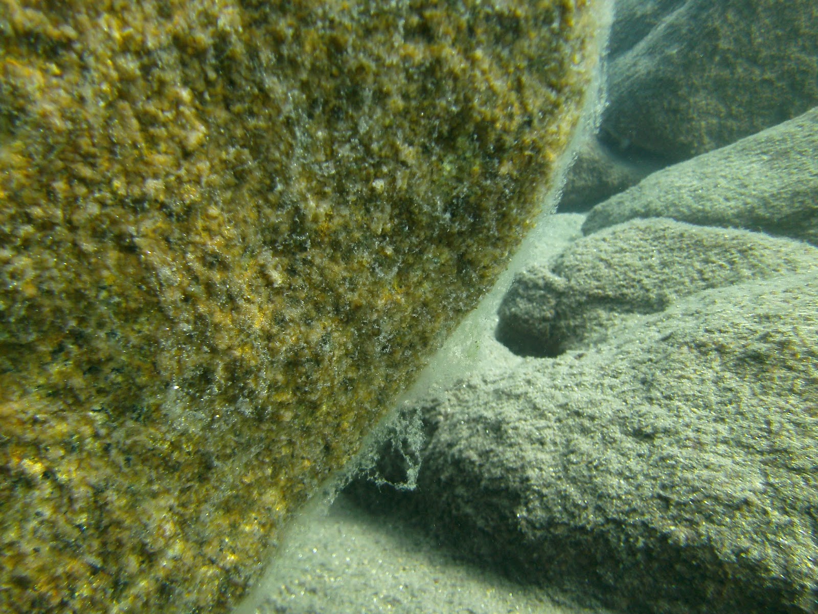
One of the 7 Periphyton (Algae) growth stations - 100ft. 

2 bricks uncovered, 2 covered, Temp sensor #5

As in any dive mission of an inaugural nature, the unknowns are many.  Upon completion of this dive we could really see the shortcomings and began a much better mission plan for the establishment of the second transect to be placed at Stateline Point.  The most notable realization is that this dive requires two teams of divers.  One to handle the establishment of the transect line and the 200 foot and 135 foot stations  and that same team moving up and completing decompression while establishing the 9 foot and 3 foot stations.  The second team would drop to 100 feet and establish that station, the 65 foot station and the 33 foot station and complete their dive by gathering algae samples from bottom rocks at the 33 foot and the 9 foot depths.

Photo Credit: NatGeo - Dr. Stan Loeb diver

An important understanding here is that what the scientists are attempting to accomplish here is a replication of a study done back in 1978-1979.  When we get all the transects in place, and collect the growth mediums (bricks) we will be able to compare to a baseline of information created over 30 years ago; no one has done this study since.  It is very exciting to be a part of this and to see the outcome and comparisons.

The other “diving" aspect of this that is real interesting is that in 1978-1979 the divers doing this initial study completed dives to 200’ with equipment of the day that was no where near as quality as the gear is today.  They did not have rebreathers, mixed gas, computers and drysuits with heaters.  They had, well... crap!  One of the divers from back then was the main student/scientist doing his dissertation, Stan Loeb: now Dr. Stan Loeb and is working out of the University of Kansas.  We had the chance to talk with him over the past several months and he told quite a few great stories.  I hope he gets to Reno someday so I can buy him a drink and treat him to lunch so he will divulge just how he pulled off these dives in wetsuits, no altitude depth gauges, AIR, single tanks, rubber masks that always leaked (silicone had not been used at the time in mask construction) and other limitations of the day.     We are very fortunate to be diving in a time where technology has kept pace keeping us safe and warm. 

We exited the water at 4pm and were on our way home by 5.  


Saturday, September 26, 2015

New Millennium's, Project Baseline Lake Tahoe has an incredible day at the lake. 26 September 2015

It was a great day on Tahoe both from the production standpoint as well as the weather.  NMDE divers Marc B. and Martin M. launched the boat from Cave Rock (one of 3 remaining launches around Tahoe) and were headed to Hurricane Bay by 7:30 am in anticipation of accomplishing quite a "task" filled agenda.

The day's agenda was made possible by a Grant from the Nature Fund that is managed by the Tahoe Truckee Community Foundation.  Before we continue with our report we want to thank both organizations for their dedicated involvement and environmental support of Lake Tahoe and for giving us this opportunity to share what is happening underwater around the lake.

To begin, the culmination of this days 4 dives and some 7 hours on the lake is most aptly shown in this photo collage:

This photo collage shows all three Nature Fund sponsored stations in the Northern Tahoe area.
Set and ready for data collection.  
The plan for the day was to establish a new station in Tahoe City, upgrade both the Hurricane Bay and Sand Harbor stations, clean the visibility markers & realign to the benchmark at each station and finally, to remove the old station at Carnelian Bay (as our main point of interest there was removed and the boat traffic is much too dangerous to have a station there).

In July, NMDE submitted a Grant proposal as mentioned to the Tahoe Truckee Community Foundation for the Nature Fund.  In late August we were notified that we were successful and in September we received our Grant Funds.  We immediately went to work; winter is coming and we wanted these stations in place.  This Grant focused upon Sand Harbor, Tahoe City (New) and Hurricane Bay.  In order to accomplish this task, we had three new depth/temperature board constructed, purchased the digital depth/temperature sensors, built the underwater containers for the digital sensors...well, a picture is better:

This is the compliment of "stuff" we had to make for this weekends diving - enough said!
The digital sensors arrived on 21 September- we call them our "minions" of depth and temperature, which allowed us to put everything together and schedule our dive day for the upcoming weekend.

The three Onset digital sensors and the Shuttle that launches them from the PC.
Our first stop was at Hurricane Bay, about a 40 minute boat ride on "glass" flat water from Cave Rock across the width of Tahoe as Cave Rock is on the east shore and Hurricane Bay on the West.  A cool morning with partly cloudy skies.  After launching our digital sensors (done with a PC and specialized software) at the lakes atmospheric level (11.8 psi - a high pressure ridge was present as the standard pressure at Tahoe is 11.66psi) we sealed them up and placed them in the underwater containers we built for them:

Not very high-tech but workable and "affordable" for a Non-Profit organization
Once all our equipment was ready, we geared up and entered the water.  Here at Hurricane Bay, we already had a station established so this site was simply to receive the new station gauges with the digital sensor, the instruction placard and a cleaning of the visibility markers.  This dive would be less than 30 minutes to a depth of 55 feet.  Here are two photos of the old and new stations (you can see that the new stations are easier to read from top down and have a larger and easier to read temperature gauge):

OLD

NEW

Today's benchmark readings for Hurricane Bay were 54 feet of depth with about 30-35 feet of visibility at a temperature of 62F.

Stop two was just up the road and into Tahoe City where Tahoe used to flow into the Truckee River - it presently does not as the lake is easily 2 feet below its natural rim of 6223 feet above sea level and down almost 8 feet from its high water mark of 6229 feet above sea level last seen on 28 June 2006. Here we will establish a completely new Project Baseline: Lake Tahoe monitoring station.  As we approached the area we thought we would place the new station, we were astounded as the depth was only 4 feet.  We then traveled due east (090) for about 3/4 of a mile where we got to a depth of about 20 feet and decided this is where we would place the station.  We really wanted the station to be closer to Commons Beach so that divers from the shore could visit and monitor but it simply was too shallow.  We again assembled all our station materials and lowered them over the side, geared up and entered.

Once on the bottom, boy were we in for a workout!  The bottom here was rock, all rock!  Just driving the auger into the bottom took 30 minutes, half our remaining gas, and at that, we were only able to drive the 48" auger about 16" into this bottom:

The "milky" cloud came after about 8 inches in depth to a new layer of probably clay.
Placing the visibility stakes was no easier and swinging a 5 pound sledge hammer underwater is a lot harder than it sounds!  But we persevered and after one hour we had the Tahoe City station established.  Its coordinates are N 39' 09.924 W120'07.860 so if ever you are out there in your boat and your dive gear and your GPS, please visit, record and send us your readings to nmde@att.net!

Today's benchmark readings for Tahoe City were 17 feet of depth with about 30 feet of visibility at a temperature of 64F.

Next stop was up to Carnelian Bay where we were going to remove all our existing station equipment.  The reason we established Carnelian Bay in 2012 was because there was a 25 foot long concrete fish placed there in the early 2000's.  This made a great dive feature and we put a line along the bottom leading out to it so divers could easily visit this site and help us record and monitor the changes in the lakes depth, temperature and visibility.  Well...I guess those that placed it there, decided that they no longer wanted the potential attention our station was bringing to it and I guess the potential negative impacts they might incur should there be an illegal dumping investigation so they replaced it.  They did not remove it from the lake however, as we saw the drag marks along the bottom they left when they moved it to deeper water.  We have not found its new location yet but we will - unless they put it in water deeper than 300 feet.  But for fun, here is a now "historical" photo of the Carnelian Bay Fish:

Fish located by divers in 2003 and removed in 2014 - too bad, it was a fun dive.
This was a 10 minute dive as we simply dropped down to 30 feet and removed everything; easier to take this stuff out than put it in.  Put it on the boat and headed over to Sand Harbor.

Once at Sand Harbor, its depth/temperature board already removed (we wanted to maintain consistency of analog gauges at this site - Hurricane Bay's was broken and Tahoe City...new) we simply dropped down, put in the new board and gauges along with the instruction placard (which we hope will increase participation by the sport diving community),cleaned the visibility markers and our dive day was complete.  Surfaced, exited, geared down and relaxed while having some lunch and beverages.  A truly great day.  We had to navigate some rough water from the Whittell Mansion south to Cave Rock but managed to get off the lake by 3 without incident.

Summary for this day: 4 dives, 3.5 hours of runtime on the NMDE research boat, 3 stations completely established and upgraded ready for monitoring and recording and 18 man hours of volunteer time added to our log.  What a great day!

We are presently in the process of applying for two more Grants as we still have 5 more stations to upgrade and or install  - upgrades at Bliss (yes we just installed but did not have the funding for the digital sensor) and Glenbrook and then new stations at Camp Richardson, Tahoe Keys (that should be informative) and Nevada Beach.  Presently we are trying to raise another $650 to purchase two more sensors so we can do Glenbrook and Bliss before winter.  We welcome donations, they are completely IRS tax deductible [NMDE tax ID - 88-0481587] so if the opportunity presents itself, please let us know - nmde@att.net.

In closing, as one of the 5 remaining Founding members of NMDE, I want to thank my most relied upon member, Marc B. for having always been there in support of our expeditions and research.  Without him, this weekend would not have been possible.  Thank You Marc!

Remember to "Like" - New Millennium Dive Expeditions on Facebook - This is where our original posts and notifications begin.  Love to see you there.  Thanks

Some additional photos, Enjoy...

The instructional placard on all stations

Heading back to Cave Rock

Marc supervising my work at Hurricane Bay - The Alley Cat below him

A beautiful Fall Tahoe Day


Sunday, August 30, 2015

NMDE/Project Baseline: Tahoe, 30 August 2015 - Sand Harbor - Station Evaluation

Today, NMDE members Martin M. and Vanessa B. headed out to Sand Harbor to "get wet", check out our Project Baseline: Lake Tahoe dive station - soon to be upgraded and sponsored by the Tahoe Truckee Community Foundation - and then head out to the inner wall about 1000' off the beach.

Our first stop for the dive was at our PBLT Station.  We set this up in 2012 and have had a variety of entries since its inception.  When we set the station, the depth was at 26 feet; today? 19 feet.  The image below is Vanessa checking the reading...


The depth/temp board as you can see is difficult to read but we just received a grant from the Tahoe Truckee Community Foundation that will allow us to upgrade this station with a top down depth/temp board - To be installed in September.  The new design will allow a diver to float directly over the top of the gauges and take their reading.

Taking a reading for PBLT only takes about 60 seconds.  A diver looks at the depth gauge and temperature gauge on our depth benchmark, notates that.  Then looks off to the west noting the visibility markers...
Martin placing a typical "visibility" marker - this is 30 feet from the benchmark.

Once a dive team has this data, then they can email it to us nmde(at)att.net.  If they have photo/video capability, we want them to take a photo of the boulder to the left of the station and the dive team can also include that image in the email.  When we receive that email,  we then take that data and image and put it on our Global database; projectbaseline.org

Once we completed our data notations and photos, we continued out along a bearing of about 220 staying right next to the boulders to our left.  We noticed thick clumpy green bottom algal growth, not attached to rocks but floating in patches on the sandy bottom - never before noticed to be this dominant a bottom feature during a dive.  The thickest concentration was between 18 feet and the30 feet with an obvious reduction in dominance above and below this depth range.  The algae (?) completely dissapated at about 31 feet.

Metaphyton Algae build up right next to the "barge"  - 18 feet depth.

Our dive was 95 minutes to a max depth of 70 feet.  The lake state was choppy with 1 foot waves due to winds the previous day continuing into our dive.

Today's PBLT Stats:

  • Depth - 19
  • Temp - 66
  • Vis - 60 feet


OTHER IMAGES:

The green clumpy metaphyton algae resting on sandy bottom - for scale - a 4 inch double ender was placed on bottom.
This algae is a combination of crusty blue-green algae and green filamentous algae maybe even some Spyrogyra


Attached periphyton algae on the granite boulders.  30 feet of depth; now dying off late in the growing season.

Wednesday, August 5, 2015

Cal Neva/Stateline Point - 150' transect north and attached algae (periphyton) sample collection


Stateline Point, on the Nevada/California Border (just below the CalNeva Hotel):

Lake Tahoe looking Southeast 

On Wednesday 5 August, 2015, New Millennium Dive Expeditions, Project Baseline: Lake Tahoe divers Martin M. and Todd K., supported by Bay Area Underwater Explorer’s member and Global Underwater Explorer’s Instructor, Beto N. as videographer, conducted one of the rare (last done in 1978-1979) exploration and algae collection dives off the east side of Cal Neva Point in Nevada; also known as Stateline Point.
  
The goal was to visually compare the attached algae (periphyton) growth on the granite walls of the north end of the lake as compared to the south end (specifically the Rubicon Wall) and take attached algae samples from a depth of 160 feet all the way to a depth of 20 feet in 20 foot increments (160, 140, 120, etc.); last time this was scientifically done was by Stanford Loeb in 1978-1979.  

Beto and Todd:
Discuss the JJ & KISS rebreathers

The day began at 7am to set-up, organize and load our equipment.  This specific Mission was going to be executed by utilizing our rebreathers and to our knowledge, another first for Lake Tahoe (a scientific mission utilizing rebreather technology- Todd and Martin using JJCCR's and Beto using a KISS CCR).


We arrived at the lake about 10am and began unloading and staging all our equipment for the dive.  Each diver was using a rebreather, an underwater Dive Propulsion Vehicle (DPV or Scooter) and stage tanks for emergency gas if needed.  All had to be transported down to water’s edge and into the lake for all divers to access it and gear-up.  Normally this would not be much of a physical issue but with the lake some 10 feet low as compared to 2011, the distance we had to travel carrying all our gear was maximized.   


Martin on top of the erosion circles

By noon we were in the water, geared-up, and had completed all our safety checks, pre-breathed our rebreathers and began to head east toward the wall. Along our path in the shallow water we came upon the “swiss cheese” looking flat granite rocks that demonstrate the weathering that created these formations before the lake level submerged them.  As we continued for another 10 minutes, the sandy and boulder ridden bottom began to fall away into a deep blue abyss and this is where it got real fun; and cold... as we hit the first thermocline at about 55 feet, much shallower than expected (70 feet on the eastern shores).   

Boulders at 150/160 feet

We descended to the 150/160 foot range and began heading north along the drop-off (not sheer granite like Rubicon).  We scootered over some very incredible rock formations, sand chutes, rock precipices, monster boulders and desolate sand flats; a very diversified geologic structure not seen in Tahoe in one location. We passed through 2 very distinct thermoclines; one around 50/55 feet and the second at about 120 feet. This drop-off had some real unique character to it.  Water temp down there was about 46 F so after 30 minutes, we turned and headed back (our plan was for 60-70 minutes total time at 150/160 feet). What was very obvious during our 60 minute scooter ride is that the attached algae here was not as thick and voluminous as the attached algae on the Rubicon wall but the visibility was very similar; about 40-50 horizontal feet; maybe a bit more in places.  


After our 60 minute run, it was time to start collecting algae samples for the scientists at UNR.  Our first collection depth would be at 150 feet.  Upon finding a suitable location to take a sample on a nice flat rock, facing up, about 3 feet in diameter, we got out our sampling kit and began our work. 
  
digression here is in order.  As mentioned earlier, the last time this was done was back in 1978-1979 by a Graduate Student for UC Davis named Stanford Loeb.  When he did this some 35 years ago, he presumably used a wetsuit, conventional SCUBA equipment and if he had double tanks, that would have been rare so we continue our assumption that he used a single tank and was breathing air.  Now at our depth of 150/160 feet, breathing air today would be considered "unsafe" due to extreme gas narcosis (today we add helium to our breathing gas, lowering the nitrogen normally found in air,which eliminates the narcotic effect of nitrogen at depth)especially in the 150/160 foot range.  Back then, air was all that was probably available and Mr. Loeb had a job to complete and in so doing had to use what was available.  Now as mentioned, in the 150/160 foot range breathing air is a safety concern but... this dedicated scientist took his experiment to  depths of 195 feet and not only once but in 7 different locations around the lake; the other consideration here is decompression tables and we can only assume he used the Navy tables, modified for altitude.  All this said, Stanford Loeb, was successful in all his dives as in 1980 he published his Dissertation.  At some point in the future, we will attempt to replicate his dives bringing back present day samples so as to compare to his 1980 publication; as Project Baseline: Lake Tahoe endeavors to establish a baseline set of data for water clarity in the Nearshore zone, Mr. Loeb established a baseline for attached algae (periphyton) in 1980 that our future efforts of data collection will be compared. 

Back to the present.  5 August, 2015.  As we found out, the sampling device that we used, designed by Stanford Loeb in 1978 was not easy to use.  For us we found the device flimsy but that said, it was our first time using it.  We only had two devices with us and our first attempt at 150 feet (image to left) was a failure but our second attempt at 80 feet was a success.  I think a more robust modification to the sampling device may be in order. We want to thank the Tahoe Environmental Research Center(TERC), operated by UC Davis, for supplying us with the collection devices. 
   
As we moved up the wall, we took rock samples at each depth.  Placed those samples in pre-marked zip lock bags and collected these samples as we decompressed from our 60 minute scooter run along the wall earlier.  In all, the 2 hour and 44 minute dive was very successful and unbenounced to us, was in one of the 1980 Loeb study locations – Stateline Point.  Pretty cool.   

The lake was a bit choppy from a southerly wind (normal for Tahoe this time of year) and as we exited from our dive we had to shuttle our scooters and stage tanks through the very shallow waters and unto the beach which took a few minutes and we exited the water just about 3:30pm.  A very productive day and a huge learning experience that will definitely benefit us on future missions.  

More Photos of the day:    

Another Boulder pile at about 160 feet


Todd pre-breathing his JJ CCR prior to the dive.


Martin pleased with his 10 pound bag of rock samples from the deep!


Beto's selfie with his newly recovered Ray Ban Classics!


Friday, July 24, 2015

Project Baseline Weekend - July 24-26 and the SoCal GUE Team of Fulks, Fulks and Millington

We are proud to report (okay…”Blog”) that our efforts in building Project Baseline: Lake Tahoe were immeasurably supported July 24-26, by a SoCal contingent of GUE trained divers that took their personal time to come to Reno and support New Millennium and its Project Baseline: Lake Tahoe endeavor.  The overall weekend goals were two fold.  Mission One, establish the fifth underwater, Project Baseline: Lake Tahoe, monitoring station at Bliss State Park and Mission Two,  conduct two video transect dives along the Rubicon Wall (between Bliss State Park and Emerald Bay) at 150 feet, recording the spread and growth of attached algae (periphyton) at depths far below that which present science is recording (15 feet to the surface and above).   

Pete, Trevor, Martin, Steve and Marc (L-R)
New Millennium divers Martin M., Marc B. (Boat Captain) and Peter F., along with GUE Instructor Steve M. of LA SCUBA Diving and Trevor F. of Partial Pressure Productions, all GUE trained divers, not only accomplished the goals mentioned above but all enhanced their personal connection with the underwater world, supported science in understanding better what is happening below the surface of Lake Tahoe and by their very actions, effected positive change for the future of the lake. Thanks Martin, Marc, Peter, Trevor and Steve! 

The first Mission, (Friday, 24 July) was to establish the monitoring station on the underwater sandy point where the beach at Bliss State Park ends and the granite wall begins.  This monitoring station contains a depth and temperature gauge, distance markers every 10 feet away from the station benchmark that allows divers to accurately determine visibility and a station placard that identifies the station and provides instructions for use.   

Our video here shows the work that was done in successfully establishing this station but what it does not show is the almost 1 knot current flowing north up and over the abyss of the Rubicon Wall.  We all enjoyed the fresh water flowing by.
  

If you can not view the video above, click here.

The total Mission time was about 45 minutes in the water with 30 minutes on the bottom setting up the station as a team.  The station rests in 25 feet of water.  Temperature was 62 f and the visibility was just 40 feet; not quite what you might expect for Lake Tahoe.  
[Station GPS location: 38.999598, -120.095012]

Mission two was to be conducted during two separate deep dives along the Rubicon Wall.  Dive One took off right from the newly established monitoring station (Friday, 24 July).  The divers descended quickly to a depth of 150 feet and began a video transect at this depth looking at the growth and spread of the attached algae (periphyton) on the massive boulders and granite walls this area is famous for (video below)... 


It was an eye opener for all! This algae, and in some places a type of “sponge” growth (probably another type of algae) was present along the entire transect and became more prolific as the divers came shallow to complete their decompression.  

Some of our equipment, at waters edge -
waiting patiently for someone to claim!
Dive Two (Saturday, 25 July) was a continuation of this deep transect from Dive One’s ending spot to just about 1500 yards north of the entrance to Emerald Bay.  On Dive Two, much of the same algae and sponge growth was noticed.  The divers also reported three distinct thermocline levels (dramatic changes in the temperature of the water).  One at 60 feet, then again at 90 feet and the final thermocline at 120-125 feet where the water temperature was between 44 and 46 degrees Fahrenheit.  Visibility was also very inconsistent; at depth the divers we experiencing about 30-40 feet but shallower and toward the end of the dive, the visibility improved to about 50 feet.  Deeper there seemed to be a lurking “white cloudy” substance in the water.  

Statistics: 
Dive One - 157' w/ total run time of 87 minutes / Dive Two - 154' w/ total run time of 75 minutes

We leave you with this thought:  

Environmentally speaking, globally, which is what we support, our personal efforts are, “to effect positive change within the world’s aquatic environments that are measurable in terms of improvement within our lifetimes”.  The sad fact is that science by itself is incapable of achieving this.  What is needed is you, us,“society” to become involved and the only way that is going to happen is to reconnect people with the world outside (underwater in our case) and visually demonstrate to them ("Baseline Shift") how our world is being effected by “society” and our decisions for energy, transportation, living, etc.;  bottom line….What society today is doing to our world; specifically underwater in our case. New Millennium, Global Underwater Explorers, Project Baseline and Project Baseline: Lake Tahoe all feel strongly that this re-connection of the “people” to the outside world (underwater) is going to be the fuel for environmental improvement.  

4 MORE PHOTOS:

The Dive Team - Trevor, Martin, Pete, Gil (Rescue Support) and Steve


Steve at the 22 minute, 20 foot decompression stop.


Peter and Trevor also hanging at the 20 foot stop.


Martin, "Hey guys...wait for me"!  Lagging behind as usual!